|
 |
Main screen
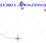
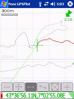
- The direction of displacement or a compass as well as the course is displayed in top on the right
 : The figure always indicates the course : The figure always indicates the course
 : An arrow indicates the direction : An arrow indicates the direction
 : A compass indicates north. : A compass indicates north.
- If it is in red: it is for the current position
- If it is in green: it is for the point of the track.
- The curve in blue in bottom, represents the variations of altitude
 Display the level of the battery (In blue during the load) Display the level of the battery (In blue during the load)
- By pressing 1 sec (a sound must resound) on the screen or by pressing on key OK, you display the main menu
- By pressing the gauge reception
 , you display the the page of the satellites (a red cross indicates that The GPS is desabled , you display the the page of the satellites (a red cross indicates that The GPS is desabled  ) )
- By pressing on the bottom of the screen, you change displayed information:
- Coordinated:

- Speed / Altitude / Distance:

- Time / Duration from 1st point of the track

- In manual zoom: By pressing on the screen (short press) you display button bar
 allow you to change the zoom (move your pen up an down) allow you to change the zoom (move your pen up an down)
 allow you to adapt zoom to display all active points and the track. By double-clicking, your center also the display allow you to adapt zoom to display all active points and the track. By double-clicking, your center also the display
 Manual position: alow you to move on the map (move your pen right and left or up an down). Manual position: alow you to move on the map (move your pen right and left or up an down).
 Zoom proportional to map Zoom proportional to map
 Allow you to move on the track (move your pen right and left) Allow you to move on the track (move your pen right and left)
 Allow you to do measurements Allow you to do measurements
- If the icon
 appears , a map is loading. appears , a map is loading.
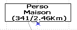
- By clicking on a point, you display his group, name, the course and outdistance (from current position)
- You can update a point from a double clic
|
|
 |
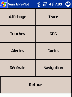
Main menu
|
|
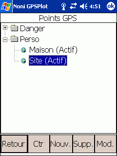 |
1 ) List points
Display the points an allow you to modifiy them.
- Show : (If a point is selected) Allow you to centre the map on this point (The display switch to manual zoom)
- Nav : (If a point is selected) Allow you to to switch in navigation to mode
- Supp. : Suppress the point or group
By suppressing the group, you suppress all points of the this group.
- Upd. : Modify a point or all points of a group
By modifing a group, you modify all points of this group.
- New. : Add a new point
- Alpha/Dist: (If a group is selected) Allow you to displyed points of the group ordered by name or by poximity
|
|
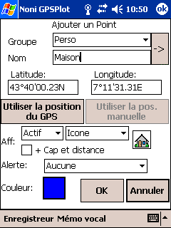 |
1-1 ) Add modify a point
Clic on  to assiciate an icon to the point. to assiciate an icon to the point.
It is possible to add icons by adding .bmp (format 22x22, the white color is considered as transparent) in the folder where NoniGPSPlot is installed (usually \Program Files\NoniGPSPlot)
- Display:
- Type:
- Active: The point is displayed and used for automatic zoom
- Displayed: The point is displayed but ignored for automatic zoom
- Desactivated: The point is ingnored
- Label:
- Group/Nom: The point is displayed as his group and name
- Group: The point is displayed as his group
- Nom: The point is displayed as his name
- Icon: The point is displayed as his icon
- course and distance: If checked, the course, the distance (relative to the current position) and the remaining time (if you goto is direction of this point) will be added to the name:
 . .
- Alert: Allow you to add a proximity alert to this point
- Color: Color of the point
|
|
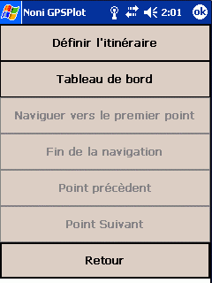 |
2 ) Navigation
- Navigate to: Allow you to selected a point and start navigation
- End of navigation: Quit navigation mode
- Route: Menu of route
|
|
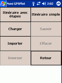 |
2-1 ) Route (Main menu)
- Route: Setup your route
- Naviguate to first point: Start navigating to first point of the route
- Previous point: Restart navigating to the previous point
- Next suivant: Start navigating to the next point
- Import: Import a route from a, external file of points (KML, GPS, CSV ou ASC)
- Invert: Invert the route
|
|
 |
2-1-1 ) Itinerary
- Naviguate to : Start to navigate to the selected point
- Add: Add a new point from the liste of points
- Suppr: Suppress the selected point from the route
- Display: Display the route
- Up: Rise the selected point up
- Downd: Rise the selected point down
|
|
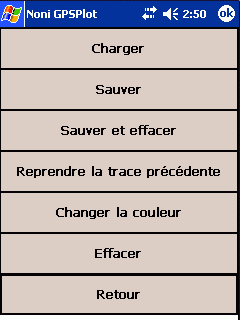 |
3 ) Tracks
|
|
 |
3-0 ) The tracing
This function is reserved to donors
- Tutorial
Not yet translated, sorry...
|
|
 |
4 ) Tools
- Import :
- Tutorial
Not yet translated, sorry...
|
|
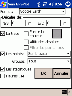 |
4-1 ) Export
- Tutorial
Not yet translated, sorry...
Allow you to export file in GoogleEarth, CSV, GPX or texte format
- Shift of: Allow you to shift the exported track:
A positive N/S value will shift the export to Nord
A positive E/W value will shift the export to l'Est.
- The track: Check to export the track
- Force color Allow you to force another color
- Absolute altitude Not recommended, except for flight
- Filter static points Avoid to have several points at the same time or place
- The points: Check to export points according to criterias
- Les statitics: Check to export statistics
- Times UTC : If checked, time of points will be saved in UTC, else in local time.
 -> ->
|
|
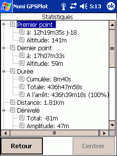 |
4-2 ) Statistics
If a part of the track is selected, (boutton and ), the informations only concern the party selected.
|
|
 |
4-3 ) Graphics
- Conf.: Change the displayed graphics (Reserved to donors)
- Show : Display the selected point
|
|
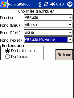 |
4-3-1 ) Selection of graphics
Fonction reserved to donors
Allow you to select the graphic you wan to display.
|
|
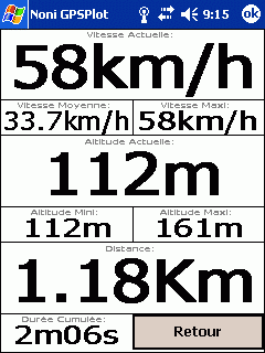 |
4-4 ) Dashboard
You can change the displayed values by clicking on it (reserved to donors).
|
|
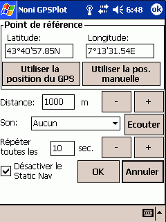 |
4-5 ) Drift alarm
Used to trigger an alarm if it moves away from more than a certain distance from one point.
|
|
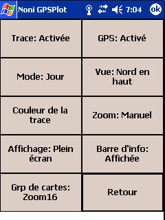 |
5 ) Quick setup
Allows you to quickly change the status of some parameters.
- Grp of maps : Allows directly activate a group of cards (the other groups will be desactivated).
|
|
 |
5 ) Advanced setup
|
|
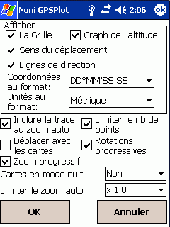 |
6-1 ) The display
- Restrict the number of points : Limit the number of points to guarantee at least 3 frames per second.
- Move with maps : Force the display of maps during manual moves.
- Smooth rotate : The change of direction in vue 'in the direction of travel' will be made gradually.
- Limit auto zoom to map : Limit le automatic zoom regarding maps.
|
|
 |
6-2 ) The GPS
- Corr. Geoide: Allows the correction of the height of the géoide in meters.
For France the average value is about 48m, it is possible to get the exact value of its region HERE
If option 'Upd auto' is checked, this value will be automatically overwritten with that provided by the GPS.
- Update time: The time of the PDA will overwritten with that provided by the GPS.
- Vérify NMEA: Verify that the GPS is in mode NMEA
- Initialize NMEA: Initialize the mode NMEA at GPS starting
- Static Nav: Allows viewing and changing StaticNav.
|
|
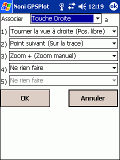 |
6-3 )The keys
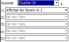
It is possible to combine several actions to a key:
In this example, the right button will turn sight to the right in manual position (button ),
Otherwise it will go to the next item on the track in move on track mode (button ),
Otherwise it will zoom +
Liste des actions par defaut:
- Key OK: Main menu
- Key UP: Turn vue at north on the top (free position ), or add point
- Key Right: Next point of the route (in navigation mode), sight Turn to the right (free position ), or point following the trail (moving on the path ), or Zoom +
- Key Left: Previous point of the route (in navigation mode), the sight Turn to the left (free position ), or Point previous track (moving on the path ), or Zoom -
- Key Down: Quick setup menu
It is also possible to associate a customizable menu to a key: The favourites menu
|
|
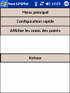 |
6-3-1 ) The favourites menu
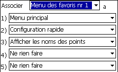 In this example, the key Ok has been associated with the Favorites menu number 1, which gives access to the Main menu, Quick Menu setup, and action displaying the names of points.
|
|
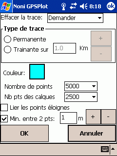 |
6-4 ) The track
- Suppress :
- Automatic: The track will be suppressed at GPS fix time if the previous point is more than 2 hours old.
- Never: The track is never suppressed.
- Aks: The question is asked at start time.
- Number of points: It is possible to setup the max number of points of the track (from 1000 to 30000). Once the limite is riched, 2 points will me merged.
A number of points too low can lead to a wire.
Example:
Track of 500 points and 21Km length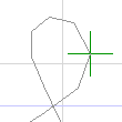 , ,
and with 1000 points 
An increasing number student loading time and memory usage.
- Min. between 2 pts:
If this option is checked you will have to go far from this distance before a new point will be added to the track.
Otherwise, new points will be created even if there is no displacement (can be useful for Graphics and Statistics).
- Join far points:
At a loss of signal (passing through a tunnel, for example) The track will be an "empty" 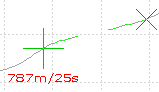
if this option is checked, the points will be linked: 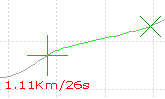 . .
It also influence the length and duration of The track.
|
|
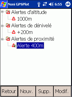 |
6-5 ) List of alerts
It is possible to add new sounds by copying .wav file in the directory where NoniGPSPlot has been installed (usually \Program Files\NoniGPSPlot)
|
|
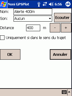 |
6-5-1 ) Proximity alert
- Tutorials
Not yet translated, sorry...
Not yet translated, sorry...
|
|
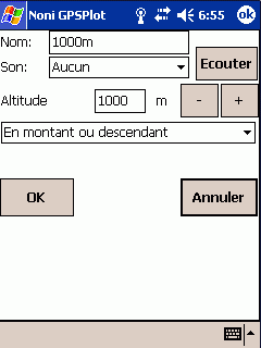 |
6-5-2 ) Altitude alert
|
|
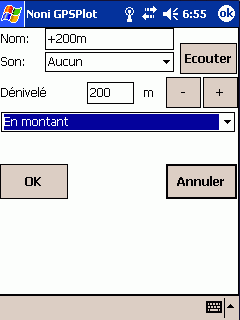 |
6-5-3 ) Uneven alert
|
|
| |
6-5-1 ) Alerte de proximité
- Tutorials
Not yet translated, sorry...
Not yet translated, sorry...
By choosing 'Voice Memo of the point', the voice memo of the point that triggered the alert will be played
|
|
| |
6-5-2 ) Altitude alerte
|
|
| |
6-5-3 ) Uneven alerte
|
|
 |
6-6 ) List of maps
The saving of map's configuration is reserved to donors
It is possible to define several maps to get a general view of the region and a detailed view of the place you want to go.
The group name of the card is the name of the directory in which it is located.
- Import a dir. To import all .map of a directory. If a .map have not been imported, try to manually create a map to know the error (reserved to donors)
- Correct Lets make simple adjustments on the cards
Icons signification:
-
 Map loaded Map loaded
-
 Map unloaded Map unloaded
-
 Map waiting to be loaded Map waiting to be loaded
-
 Map loading Map loading
-
 Map waiting for memory to be loaded Map waiting for memory to be loaded
-
 Map in error Map in error
|
|
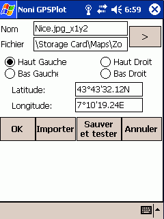 |
6-6-1 ) Configuration of the maps
- File : Name of the file
- If you're using BMP, back in the 256 colors to save memory.
- All cards are loaded into memory! Beware of memory available.
- It is necessary to define the coordinate of the 4 corners of the card
- Import : Allow you to import a .map file.
|
|
 |
6-7 ) Common
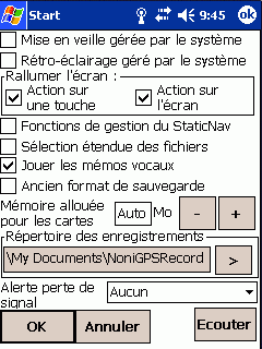
- Turn Off managed by system : If this option is checked, Turnning off of the PDA depend on the system parameters.
Otherwise, NoniGPSPlot keep your PDA on.
- Backlight managed by the system : If this option is checked, the extinction of the screen and/or backlight depend on the system parameters.
Otherwise, NoniGPSPlot keep your screen on.
- Turn screen on : Allows you to set the trigger sources to turn display on.
Caution: All PDAs do not react the same way to the function.
- Function to manage StaticNav : To enable the advanced features StaticNav management.
Using these features is' at your own risk '.
- Play voice memo : If a voice memo is associated with the point, it will automatically be played when you click on the point on the screen or in the list of points
- Extented file selection: Allows you to stop using the 'standard' windows for selecting files, but a window for selecting a file anywhere on your PDA.
- Memory allocated for maps: Allows you to define the allocated memory for maps.
- Alert no signal: Allows you to set a sound to warn of the loss of the signal.
- Voice records maps : To select the folder where the voice memo are saved.
|
|
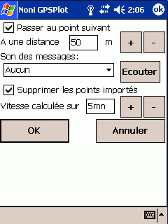 |
6-7 ) Navigation
- Go to next point : If this option is checked, NoniGPSPlot pass automatically to the next point on the route.
- Message sound : If this option is selected, the ring during messages related to navigation.
|
|
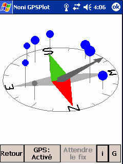 |
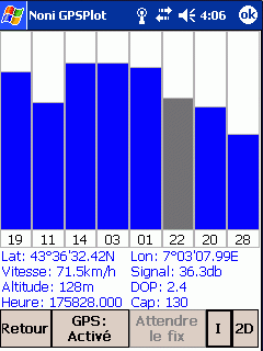
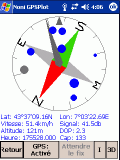
7 ) Satellites
- 2D : Display satellites status in 2D
- 3D : Display satellites status in 3D (It is possible to change the view by dragging the stylus from top to bottom and from right to left)
- G : Display satellites status as graphics
- I : Displays/Hide details
|