|
 |
Main screen
- The bearing in degrees and a comprass needle or direction arrow is displayed in top on the right
 : The number show the arrow's direction in degrees : The number show the arrow's direction in degrees
 : An arrow indicates the direction : An arrow indicates the direction
 : A compass indicates north. : A compass indicates north.
- If it is in red: it is for the current position
- If it is in green: it is for the point of the track.
- The curve in blue at the bottom, represents the variations of altitude
 Display the level of the battery (In blue while loading) Display the level of the battery (In blue while loading)
- By pressing 1 sec (a sound is played) on the screen or by pressing on key OK, you display the main menu
- By pressing the gauge reception
 , you display the the page of the satellites (a red cross indicates that The GPS is desabled , you display the the page of the satellites (a red cross indicates that The GPS is desabled  ) )
- By pressing on the bottom of the screen, you change displayed information:
- Coordinates:

- Speed / Altitude / Distance:

- Time / Duration from 1st point of the track

- By pressing on the screen (short press) you display button bar
 Increases the zoom Increases the zoom
 Decreases the zoom Decreases the zoom
 Allows you to freely change the zoom (slide your pen up an down) Allows you to freely change the zoom (slide your pen up an down)
 Allows you to adapt zoom to display all active points and the track. By double-clicking, your center also the display Allows you to adapt zoom to display all active points and the track. By double-clicking, your center also the display
 Manual position: alow you to move on the map (move your pen right and left or up an down). Manual position: alow you to move on the map (move your pen right and left or up an down).
 Zoom proportional to map Zoom proportional to map
 Allows you to move on the track (slide your pen right and left) Allows you to move on the track (slide your pen right and left)
 Allows you to take measurements Allows you to take measurements
 Actions configurable in the buttons menu Actions configurable in the buttons menu
 Add a new point Add a new point
- If the icon
 appears , a map is loading. appears , a map is loading.
- If the icon
 then then  appears, a map is been downloading then processing. appears, a map is been downloading then processing.
- If the icon
 appears, a network is blocking the download. appears, a network is blocking the download.
- By clicking on a point, you display his group, name, the course and outdistance (from current position)

- You can update a point with a double clic
|
|
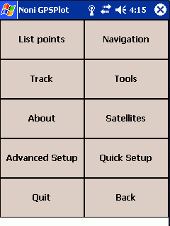 |
Main menu
|
|
 |
1 ) List points
Display the points an allow you to modifiy them.
- New. : Add a new point
- Alpha/Dist: (If a group is selected) Allow you to displyed points of the group ordered by name or by poximity
- >: Provides access to additional options (edit, delete ...)
|
|
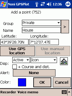 |
1-1 ) Add modify a point
Clic on  to assiciate an icon to the point. to assiciate an icon to the point.
It is possible to add icons by adding .bmp (format 22x22, the white color is considered as transparent) in the folder where NoniGPSPlot is installed (usually \Program Files\NoniGPSPlot)
- Display:
- Type:
- Active: The point is displayed and used for automatic zoom
- Displayed: The point is displayed but ignored for automatic zoom
- Secondary: The point is displayed only if the scale and lower than 10Km. This type is useful when you have a great number of points which make illegible your maps (as the radars for example) (it is not taken into account for the automatic zoom).
- Desactivated: The point is ingnored
- Label:
- Group/Nom: The point is displayed as his group and name
- Group: The point is displayed as his group
- Nom: The point is displayed as his name
- Icon: The point is displayed as his icon
- course and distance: If checked, the course, the distance (relative to the current position) and the remaining time (if you goto is direction of this point) will be added to the name:
 . .
- Alert: Allow you to add a proximity alert to this point
- Color: Color of the point
|
|
 |
1-1-1 ) Alert associated to a point
- Alert: Select the alert
- If speed >: If this option is checked, the alert did trigger only if the speed is the greater than the value
- f course: If this option is checked, the alert did trigger only if one is the direction
- Get from track: Try to determine the direction from the recorded track
|
|
 |
2 ) Navigation
- Setup the route: Setup your route
- Dashboard: The navigation dashboard
- Naviguate to first point: Start navigating to first point of the route
- End of navigation: Quit navigation mode
- Previous point: Restart navigating to the previous point
- Next point: Start navigating to the next point
- Next item on my way: Search the nearest point in my direction
- Man Overboard: Sets navigate to your current position. Click again to stop this function
|
|
 |
2-1 ) Route (Main menu)
- Route with steps: Setup your route with several steps
- Simple route: Setup a route simply by choosing the point of destination
- Load: Load a route
- Save: Save the current route
- Navigate to: Allow you to selected a point and start navigation
- Import: Import a route from a, external file of points (KML, GPS, CSV ou ASC)
- Invert: Invert the current route
|
|
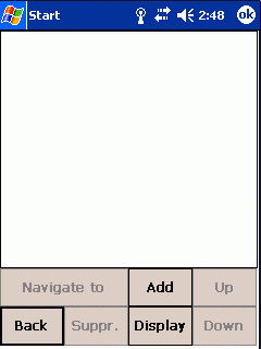 |
2-1-1 ) Itinerary
- Naviguate to : Start to navigate to the selected point
- Add: Add a new point from the liste of points
- Suppr: Suppress the selected point from the route
- Display: Display the route
- Up: Rise the selected point up
- Downd: Rise the selected point down
|
|
 |
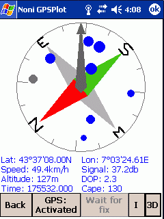
2-2 ) Dashboard for navigation
You can change the displayed values by clicking on it (reserved to donors).
- The biggest blue arrow indicates the direction of the current point
- The average arrow indicates the direction of the next point
- The light arrow indicates the direction of the destination
|
|
 |
2-2 ) Dashboard for navigation with features for timing
|
|
 |
3 ) Tracks
|
|
 |
3-1 ) The tracing
This function is reserved to donors
|
|
 |
4-1 ) Export
Allow you to export a track file in GoogleEarth, GPX or others format
- Shift of: Allow you to shift the exported track:
A positive N/S value will shift the export to Nord
A positive E/W value will shift the export to l'Est.
- Force color Allow you to force another color
- Absolute altitude Not recommended, except for flight
- Filter static points Avoid to have several points at the same time or place
- + the points on the track: Check to export points on the track
- Les statitics: Check to export statistics
- Times UTC : If checked, time of points will be saved in UTC, else in local time.
 -> ->
|
|
 |
4 ) Tools
- Import points:
- Search an address: Allows searching an address if you have an Internet access
|
|
 |
4-1 ) Export points
Allow you to export your points in GoogleEarth, CSV, GPX or texte format
- Shift of: Allow you to shift the exported track:
A positive N/S value will shift the export to Nord
A positive E/W value will shift the export to l'Est.
|
|
 |
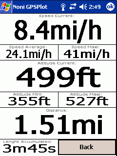
4-2 ) Statistics
If a part of the track is selected, (boutton and ), the informations only concern the party selected.
|
|
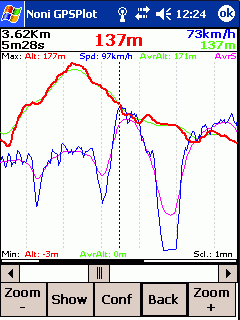 |
4-3 ) Graphics
- Conf.: Change the displayed graphics (Reserved to donors)
- Show : Display the selected point
|
|
 |
4-3-1 ) Selection of graphics
Fonction reserved to donors
Allow you to select the graphic you wan to display.
|
|
 |
4-4 ) Dashboard
You can change the displayed values by clicking on it (reserved to donors).
|
|
 |
4-5 ) Dashboard with features for timing
|
|
 |
4-6 ) Drift alarm
Used to trigger an alarm if it moves away from more than a certain distance from one point.
|
|
 |
4-7 ) Search an address
This function requires an Internet access
Allows to search for the position corresponding at an address
|
|
 |
5 ) Quick setup
Allows you to quickly change the status of some parameters.
- Grp of maps : Allows directly activate a group of cards (the other groups will be desactivated).
|
|
 |
5 ) Advanced setup
|
|
 |
6-1 ) The display
- Restrict the number of points : Limit the number of points to guarantee at least 3 frames per second.
- Move with maps : Force the display of maps during manual moves.
- Smooth rotate : The change of direction in vue 'in the direction of travel' will be made gradually.
- Maps in night mode : Used to darken the cards in the night mode.
- Limit auto zoom : Limit le automatic zoom regarding maps resultion.
|
|
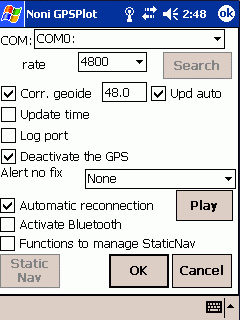 |
6-2 ) The GPS
- Search: To get the GPS settings from the Windows configuration (If your system allows).
- Corr. Geoide: Allows the correction of the height of the géoide in meters.
For France the average value is about 48m, it is possible to get the exact value of its region HERE
If option 'Upd auto' is checked, this value will be automatically overwritten with that provided by the GPS.
- Update time: The time of the PDA will overwritten with that provided by the GPS.
- Alert no fix: Allows to choose a sound in case of loss of fix
- Automatic reconnection: If the GPS does not provide more information, NoniGPSPlot close and re-open the port
- Function to manage StaticNav : To enable the advanced features StaticNav management.
- Activate Bluetooth: Activates the Bluetooth function on your PDA at the opening of GPS (Do not check if you do not have or do not use Bluetooth).
|
|
 |
6-2-1 ) Static Nav
- NMEA/Sirf rate: Internal rate of the GPS
- Vérify NMEA: Verify that the GPS is in mode NMEA
- Display status: Display current status
- Initialize mode NMEA: Initialize the mode NMEA to default rates
|
|
 |
6-3 )The keys
It is possible to combine several actions to a key:
'Button 1' and 'Button 2' can add functionality directly on the main display
In this example, the right button will turn sight to the right in manual position (button ),
Otherwise it will go to the next item on the track in move on track mode (button ),
Otherwise it will zoom +
Liste des actions par defaut:
- Key OK: Main menu
- Key UP: Dashboard (in navigation), else, add a point to the current position (free position ), or add point
- Key Right: Next point of the route (in navigation mode), sight Turn to the right (free position ), or point following the trail (moving on the path ), or Zoom +
- Key Left: Previous point of the route (in navigation mode), the sight Turn to the left (free position ), or Point previous track (moving on the path ), or Zoom -
- Key Down: Quick setup menu
It is also possible to associate a customizable menu to a key: The favourites menu
|
|
 |
6-3-1 ) The favourites menu

 In this example, the key Ok has been associated with the Favorites menu number 1, which gives access to the Main menu, Quick Menu setup, and action displaying the names of points.
|
|
 |
6-4 ) The track
- Suppress :
- Automatic: The track will be suppressed at GPS fix time if the previous point is more than 2 hours old.
- Never: The track is never suppressed.
- Aks: The question is asked at start time.
- Number of points: It is possible to setup the max number of points of the track (from 1000 to 30000). Once the limite is riched, 2 points will me merged.
A number of points too low can lead to a wire.
Example:
Track of 500 points and 21Km length , ,
and with 1000 points 
An increasing number student loading time and memory usage.
- Min. between 2 pts:
If this option is checked you will have to go far from this distance before a new point will be added to the track.
Otherwise, new points will be created even if there is no displacement (can be useful for Graphics and Statistics).
- Join far points:
At a loss of signal (passing through a tunnel, for example) The track will be an "empty" 
if this option is checked, the points will be linked:  . .
It also influence the length and duration of The track.
|
|
 |
6-5 ) List of alerts
It is possible to add new sounds by copying .wav file in the directory where NoniGPSPlot has been installed (usually \Program Files\NoniGPSPlot)
|
|
 |
6-5-1 ) Proximity alert
|
|
 |
6-5-2 ) Altitude alert
|
|
 |
6-5-3 ) Uneven alert
|
|
 |
6-5-3 ) Speed alert
|
|
 |
6-5-3 ) Climb speed alert
|
|
 |
6-6 ) List of maps
The saving of map's configuration is reserved to donors
It is possible to define several maps to get a general view of the region and a detailed view of the place you want to go.
The group name of the card is the name of the directory in which it is located.
- Import a dir. To import all .map of a directory. If a .map have not been imported, try to manually create a map to know the error (reserved to donors)
- Correct Lets make simple adjustments on the cards
Icons signification:
-
 Map loaded Map loaded
-
 Map unloaded Map unloaded
-
 Map waiting to be loaded Map waiting to be loaded
-
 Map loading Map loading
-
 Map waiting for memory to be loaded Map waiting for memory to be loaded
-
 Map in error Map in error
|
|
 |
6-6-1 ) Configuration of the maps
- File : Name of the file
- If you're using BMP, back in the 256 colors to save memory.
- All cards are loaded into memory! Beware of memory available.
- It is necessary to define the coordinate of the 4 corners of the card
- Import : Allow you to import a .map file.
|
|
 |
6-7 ) Common
- Turn Off managed by system : If this option is checked, Turnning off of the PDA depend on the system parameters.
Otherwise, NoniGPSPlot keep your PDA on.
- Backlight managed by the system : If this option is checked, the extinction of the screen and/or backlight depend on the system parameters.
Otherwise, NoniGPSPlot keep your screen on.
- Turn off the screen completely : With some PDAs, turning off the screen also turned off the GPS and/or keyboard. Uncheck this option if this is the case.
- Alternative keyboard: Allows you to display a keyboard when it enters an input field
- Extented file selection: Allows you to stop using the 'standard' windows for selecting files, but a window for selecting a file anywhere on your PDA.
- Mode PNA : If you are using a PNA or you have a gray stripe at the top, check this option (need to restart NoniGPSPlot).
- Memory allocated for maps: Allows you to define the allocated memory for maps.
- Voice records maps : To select the folder where the voice memo are saved.
- Climb speed calculated over : Allows you to select the duration over which the climb speed will be calculated (you can reduce this value to increase responsiveness, but the value will be less accurate)
|
|
 |
6-8 ) Navigation
- Go to next point : If this option is checked, NoniGPSPlot pass automatically to the next point on the route.
- Message sound : If this option is selected, the ring during messages related to navigation.
- Speed calculated : Allows you to select the duration over which approach speed will be calculated (If your speed and your course remains relatively stable (as in sailing), you can reduce this value to increase responsiveness)
- Message sound : If this option is selected, the ring during messages related to navigation.
- Color : Color of lines used to display the route
|
|
 |
6-9 ) Internet Maps
This feature requires an Internet access and allows to download displayed maps in real time
If your PDA/SmartPhone does not have an unlimited Internet access, you have to use NoniMapView.
Makes it possible to configure the remote loading of the charts from Internet
- Download maps : Check to activate the downloading of the maps from Internet.
- Displayed source : The type of maps displayed
- Folder of cache : Allows to define the folder where will be downloaded the maps
- Download URL : Allows to download automatic the URL of sources
- Country Code : Allows to choose the language of the charts (it depends on the sources)
- Valid for : Number of days after which, the maps will be downloaded again (when there is nothing else to do)
|
|
 |
6-9-1 ) Sources
This function requires an Internet access
Allows choosing and configuring the sources of maps from Internet (Google Map, Yahoo Map, Virtual Earth...)
When a source is active, it will appears in the list 'Displayed source' or in the button `Group of maps' of the quick setup window.
|
|
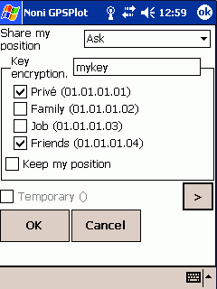 |
6-10 ) Share my position
This function requires an Internet access
Allows you to configure sharing your position system
|
|
 |
6-11 ) Shared positions
This function requires an Internet access
Allows you to configure your shared positions
|
|

 |
7 ) Satellites
- 2D : Display satellites status in 2D
- 3D : Display satellites status in 3D (It is possible to change the view by dragging the stylus from top to bottom and from right to left)
- G : Display satellites status as graphics
- I : Displays/Hide details
|