Francais
English
Espańol
Polski
Italiano
Deutsch
Main
Screen capture
Required configuration
Download
Menu
FAQs
Tutorials
License
Installation
Find you GPS parameters
External BlueTooth GPS
Installation and setup
Using NoniGPSPlot
Using NoniGPSPlot with a SmartPhone
The different zooms
Setup an alert for a point
Plan a route
Share my position
Follow a shared position with NoniGPSPlot
Follow a shared position with NoniMapView
Using maps
Organize the maps / groups of maps.
Use moving map from GoogleMap (or YahooMap, VirtualEarth, OpenMapStreet...) with NoniMapView
Calibrate a map with eMapZone
Split a big map
Automatic downloading of maps.
Miscellaneous
My GPS does not react if I'm moving too slowly: The StaticNagivation
Filter the track
Organize the maps / groups of maps.
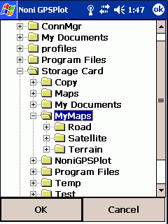
To make best use of the concept of group of maps in NoniGPSPlot, it is necessary to classify its maps as a directory per type of maps:
Example: I have maps for roads, other for terrain and other for satellite view (with several level of zoom).
I therefore create a main directory with 3 subdirectories on my PDA:
MyMaps
Road (where I copy the files for roads)
MyRoadMaps.map
MyRoadMaps.jpg
Terrain (where I copy the files to my terrain maps)
MyTerrainMaps.map
MyTerrainMaps.jpg
Satellite (where I copy the files for my satellite maps)
MySatelliteMaps.map
MySatelliteMaps.jpg
With the donor version, I can import all the directory MyMaps (Advanced Configuration menu, Maps, Import a dir.)
I therefore find myself with 3 groups of maps:
In the Quick Setup menu, I then can choose directly the group therefore the type of maps (do not select All):